Blog
14th century map of the world
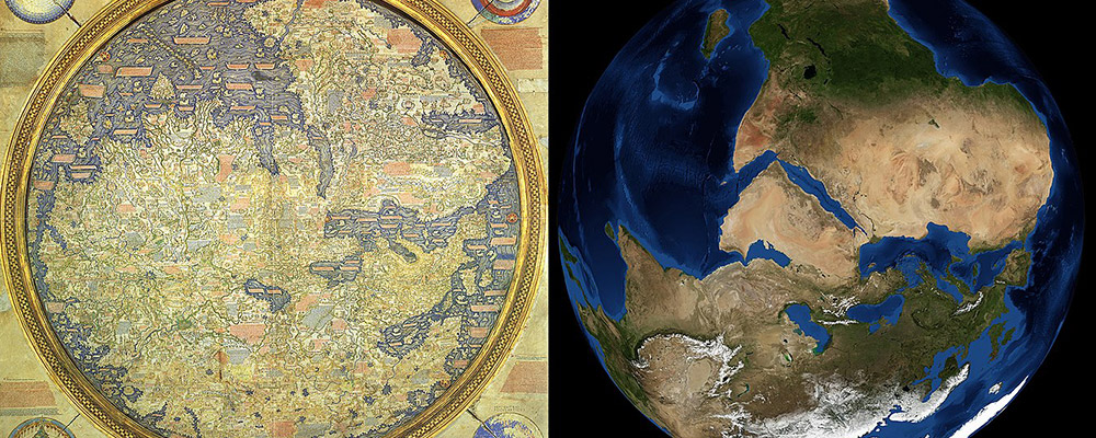
The Fra-Mauro map is a 14th century rendering of the known world by a Monk, Fra Mauro, working in Murano (1). It is a medieval master-piece. Consider this image that compares the map with one from NASA (2). Imagine this was done at a time when the Americas were not discovered, and all the information was based on information obtained from intrepid men who travelled on foot and by boat.
The map is covered with more 3000 inscriptions on the surface (3). I remember seeing the map in a museum in Venice almost two decades ago (it is placed horizontally, behind a glass case and measures about two by two meters). I recall the excitement that I felt on seeing this almost 700 year-old map and trying to find India on it! A lot has been written about the map but I am not available to find a good write-up about the parts that refer to India.
A researcher from the then Ceylon has given a fairly detailed account of the parts of the map that refer to Sri Lanka in 1915 and this makes for a fascinating read particularly as he laments the fact that it is difficult to even view the map in good detail! (4) There is some mention of Quilon as the land of pepper, black lions, indigo and white parrots with red beaks (5). Black lions and the white parrots have been referenced by Marco Polo in his account of his travels through India – I assume it refers to panthers!
This is the part of the map that references India, but I am unable to read the fine print. I will continue to explore and see if I can lay my hands on a copy of this fascinating piece of history!

The British Library has a copy of the original map, a meticulous reproduction by William Frazer made in 1804. Their website (6) has some enlarged images of parts of the map.
-
 02
02nd May, 2019 -
 admin
admin